from International Standard Bible Encyclopedia
Capernaum (kə-pûr̀nə-um [Gk Kapernaoum)]. The most important city on the northern shore of the Sea of Galilee. It was here that Jesus established His headquarters for the major part of His public ministry (Mt. 4:13). In Mt. 9:1 Capernaum is called “his own city.” At least three of Jesus’ disciples came from there. Peter and Andrew, originally from Bethsaida (Jn. 1:44), had apparently moved to Capernaum (Mk. 1:29). It was from a tax office in the same city that Matthew rose to follow Jesus (Mt. 9:9). Many miracles were performed in and around Capernaum: e.g., the paralyzed servant of the centurion was healed (Mt. 8:5–13); a paralytic, carried to Jesus by four friends and let down through the roof, picked up his bed and walked (Mk. 2:1–12); and Peter’s mother-in-law was cured of a fever (Mk. 1:29–31).
While we know Capernaum as an important place in Jesus’ Galilean ministry, its larger significance is indicated by the presence of a Roman centurion and detachment of troops (Mt. 8:5–9), a customs station (Mt. 9:9), and a high officer of the king (Jn. 4:46). That Capernaum is not mentioned in the OT is no argument against its prominence at a later period, since it may have been settled after the Captivity. Its importance is reflected in Jesus’ pronouncement of doom: “And you, Capernaum, will you be exalted to heaven? You shall be brought down to Hades” (Mt. 11:23).
There is no certain evidence that the name bears any relationship to the prophet Nahum, although an inscription found near the mouth of the Yarmuk refers to Kephar Nahum, “the village of Nahum.”
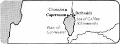
The question of exact location has been a matter of prolonged discussion. Mt. 4:13 identifies the site as “Capernaum by the sea” and Jn. 6:16–24 with Mk. 6:53 places it in or near the well-known plain of Gennesaret. Only two sites can lay serious claim to the identification: Khan Minyeh 5 mi (8 km) W of the Jordan River on the northeast edge of plain of Gennesaret, and Tell Ḥûm about 2.5 mi (4 km) NE of Khan Minyeh. Khan Minyeh lies inland along the great caravan road leading N at the junction of the eastern road heading toward Bethsaida Julias. Tell Ḥûm is immediately adjacent to the sea.
In an earlier period most scholars favored Khan Minyeh. Among the various reasons proposed were: (1) The account of the disciples and Jesus crossing the Sea of Galilee to Capernaum (Jn. 6:16–24) and coming to shore in Gennesaret (Mt. 14:34) favors Khan Minyeh. (2) Its tollhouse (Mk. 2:14) would be near the great trade route from Damascus to Egypt so as to collect revenue from the passing caravans. (3) Josephus tells us that the plain of Gennesaret was watered by the fountain of Capernaum (BJ iii.10.8), and this must surely be the fountains at eṭ-Ṭâbghah 0.5 mi (0.8 km) E of Khan Minyeh. Water from this source was led by an aqueduct around a rock cliff and into the plain at Minyeh. (4) Remains of an ancient city have been discovered between the site and the sea. (5) It is possible to find the name Minyeh in the designation of Christians as Minim, a group the Talmud associated with Capernaum.
More recently scholars have identified Capernaum with the ruins at Tell Ḥûm. Among the more important reasons are: (1) The extensive ruins at Tell Ḥûm are demonstrably ancient, with pottery from the Roman period, while the excavations at Khan Minyeh show it to be an Arab site of a much later date. (2) The name Tell Ḥûm may well be a corruption of Tankhum, a Jewish rabbi who is said to have been buried there. Less convincing is the etymology that sees Tell as the designation of Kephar after its fall, and Ḥûm as all that remains of the name Nahum. (3) The customs house would be appropriate at Tell Ḥ̂um as a place of levying taxes on the produce of the area as well as for collecting revenue from the traffic that moved eastward along the road to Bethsaida Julias. (4) Although the fountain of Capernaum was closer to Khan Minyeh, it was connected topographically to Tell Ḥûm. As each town in antiquity had its “territory,” that of Capernaum would be sufficiently large to include either or both of the sites. (5) Eusebius’ Onomasticon (a fourth-century work on biblical topography) places Chorazin 2 mi (3 km) from Capernaum. If Chorazin is best identified with Kerâzeh, Tell Ḥ̂um must be Capernaum. (6) The pilgrim Theodosius (ca a.d. 530) coming from the west arrived at the spring before he came to Capernaum. This would be far less likely if the city were situated at Khan Minyeh.
The Franciscans procured the site at Tell Ḥûm in 1894. To prevent continuous pillaging of the ruins for building stones, they covered the area with earth. Partially excavated, it has revealed a wealth of material. One of the more important ruins is a third- or fourth-century synagogue, which may well occupy the same site as the synagogue mentioned in Lk. 7:5. It measures 65 ft (20 m) in length, is two stories high, and is constructed of white limestone rather than the black basalt found in abundance in the area. The “chief seats” are along the side and are still to be seen. At the south end an ark of the law is represented in stone. The ornamentation, which includes animals and mythological figures, is not in accord with the strict interpretation of Jewish law. An Aramaic inscription reads “Alphaeus, son of Zebedee, son of John, made this column; on him be blessing.”
From the middle of the 2nd cent the region around the lake became the citadel of rabbinic Judaism. Because Christians were not tolerated in the area there was a serious break in tradition, which makes the specific identification of places such as Peter’s house highly unlikely. In the 4th cent large numbers of Christian pilgrims began visiting Capernaum.
R. H. Mounce