From International Standard Bible Encyclopedia
Beer-Shebabēr-shēʹbə [Heb be’ēr šeḇa‘; Gk Bērsabee; Eusebius (Onom 166.20f) equates Gk phrear horkismou—‘well of swearing’]. A site of major importance in the northern Negeb desert.
I. Significance of the Name
The name of this venerable town means literally “the well of seven.” The Semitic words for “oath” and “swear an oath” are derived from the consonantal root of the number seven, and this etymological relationship is stressed in the biblical explanations of the name Beer-sheba. The name was first given because there Abraham and Abimelech king of Gerar swore an oath of mutual allegiance (Gen. 21:31), and the ritual of swearing involved seven ewe lambs that Abraham gave to Abimelech (Gen. 21:28–30). The covenant agreement was aimed at resolving disputes between the two parties concerning the possession of certain wells. A similar dispute is recorded concerning Abimelech and Isaac. When agreement was finally reached and the oath duly taken, Isaac received a report from his servants that a new well had successfully been dug. In honor of this occasion, Isaac named the new well šiḇ‘â, the numeral seven (masc). “Therefore the name of the city is Beer-sheba to this day” (Gen. 26:33).
II. Geographical Situation
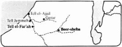
The site of biblical Beer-sheba has been identified with Tell es-Seba‘, also known as Tell el-’Imshash, “mound of the wells,” located at the juncture of the Wâdī Seba‘ with the Wâdī Khelil. The resultant stream bed continues WSW in a winding course for about 10 mi (16 km) before swinging northward in a wide arc past Tell el-Far‘ah (Sharuhen) and Tell Jemmeh (probably Yurzah, known from Egyptian inscriptions), whence it continues NW, reaching the sea near Tell el-‘Ajjûl (known from Byzantine sources as Beth-eglaim). The western segment of this stream bed was probably the biblical Besor; various wells, especially in the region of Tell es-Seba‘, serve to illustrate the appropriateness of the biblical passages cited above.
Beer-sheba is located in a topographical basin, the outline of which resembles an hourglass. As it extends eastward from the coastal plain, it narrows toward Beer-sheba; from there to the crest overlooking the Dead Sea it widens once again. Thus it serves to separate the populated region on the north, where the traditional topographical division into longitudinal belts prevails, and the desert highlands on the south, where the principal ridges swing round toward the southwest. Because of this position between the Judean mountains to the north and the Negeb highlands to the south, the Beer-sheba basin is an area of deposition rather than of erosion. This accounts for its rich alluvial soil, and especially its extensive regions of loess (a very fine blown sand). The basin itself marks the southern end of the region of permanent settlement; the 300 mm. (about 12 in) per annum rainfall line, the border of aridity, passes through it. Below this line regular agriculture could not be maintained without an artificial water supply. Therefore, the southern boundary of settlement varied from N to S in accordance with prevailing weather conditions. This territory, of which Beer-sheba was the topographical pivot, embraced the biblical Negeb.
III. Chalcolithic Culture
Extensive Chalcolithic settlement in the immediate vicinity of Beer-sheba is evidenced by numerous small mounds on both sides of the Wâdī es-Seba‘. Each of these hillocks contained the remains of a small community of underground dwellings dug in the loess. The Chalcolithic culture of Beer-sheba evidently originated in the northern Negeb; its latest stage is closely related to that of Tuleilat Ghassul. But Chalcolithic culture in this region has no connection with any of the events or peoples referred to in the Bible even though Chalcolithic sherds have also been found at Tell es-Seba‘.
IV. Patriarchal Associations
More than a millennium separated the biblical patriarchs from the Chalcolithic occupants of Beer-sheba. The Genesis accounts make no mention of a king or even of a city at Beer-sheba. The absence of Middle and Late Bronze Age sherds from Tell es-Seba‘and the immediate vicinity supports the assumption that the patriarchs encountered no sedentary population there. Accordingly, the area of Hagar’s wanderings is called “the wilderness of Beer-sheba” (Gen. 21:14). The closest cultural and commercial center was evidently Gerar, whose rulers enjoyed hegemony over the Beer-sheba district. While Abraham was located on the vital artery connecting Shur (the famous Egyptian defense line on the east) and Kadesh (-barnea), he enjoyed the status of a sojourner at Gerar (Gen. 20:1). At the same time, he enjoyed water rights in the Beer-sheba area by virtue of an agreement with Abimelech, the ruler of Gerar (21:22–32). The earliest biblical reference to the sanctity of Beer-sheba is associated with this event. Soon after this covenant with Abimelech, Abraham planted a tamarisk tree at Beer-sheba; the religious nature of this act is stressed by the added statement that there he called on the name of Yahweh the everlasting God (21:33). He evidently continued to reside in that region for some time (cf. 22:19).
A similar situation prevailed during the sojourn of Isaac in the territory of Gerar. Although Isaac dwelt for a time in Gerar itself (Gen. 26:1–16), the envy of his agricultural success and renewed disputes over water rights forced him to move, first to the “valley of Gerar” (v 17) and finally to Beer-sheba (v 23). Here he was able to reach an agreement with Abimelech like that formerly extended to his father (vv 23–33). Isaac must have remained in the Beer-sheba region for a long time; the disputes between his grown sons Jacob and Esau seem to have taken place there (28:10). But upon his return to Canaan, Jacob found his father at Hebron (35:27); Jacob evidently made this latter place his own headquarters until his descent to Egypt (cf. 46:1–7).
V. Southern Extremity of Israelite Territory
From early in the period of settlement by the Israelite tribes Beer-sheba was reckoned as the southernmost extremity of the territory, as expressed in the familiar phrase “from Dan to Beer-sheba” (Jgs. 20:1; 1 S. 3:20). The same definition was applied to the territory encompassed by Saul’s kingdom (2 S. 3:10) and maintained its validity during the reign of David (2 S. 24:2, 15; 1 Ch. 21:2). Under Solomon it served to distinguish Israel proper from the wider sphere of his dominions (1 K. 4:24f). Even after the fall of the northern kingdom of Israel, when Hezekiah king of Judah sought to expand his own influence over the entire Israelite sphere, he had a proclamation made “from Beer-sheba to Dan” (2 Ch. 30:5). Meanwhile, Beer-sheba had represented the southern limit of the Judean kingdom, for example, under Jehoshaphat, who had exercised leadership “from Beer-sheba to Mount Ephraim” (2 Ch. 19:4). Although King Josiah had extended his own authority, at least in some measure, even as far as Galilee (2 ch 34:6), the immediate bounds of his own Judean kingdom extended “from Geba to Beer-sheba” (2 K. 23:8).
During the postexilic period Beer-sheba continued to mark the southern extent of Judean settlement (Neh. 11:30).
VI. Capital of the Negeb
Beer-sheba was assigned to the tribe of Simeon (Josh. 19:2; 1 Ch. 4:28); but since that tribe had become so closely affiliated with Judah (Jgs. 1:3), the towns of Simeon also appear in the allotments made to Judah. Beer-sheba and the others are listed therefore among the towns in the “Negeb district” of Judah (Josh. 15:28; cf. vv 21, 32). Beer-sheba’s importance as an administrative center in the premonarchial period is underlined by Samuel’s having stationed his sons there to act as judges (1 S. 8:2).
The role of Beer-sheba as capital of the Negeb, the southernmost district in David’s kingdom (2 S. 24:2; 1 Ch. 21:2), is clearly seen in the record of Joab’s census. The officials sent out to take this census went “to the Negeb of Judah at Beer-sheba” (2 S. 24:7). The same administrative arrangement seems to have prevailed under Solomon (1 K. 4:24). When the prophet Elijah wished to escape from the territory under Ahab and Jezebel’s jurisdiction, he fled south; his first stop was evidently at “Beer-sheba, which belongs to Judah” (1 K. 19:3). Perhaps it was necessary to explain which Beer-sheba was intended so as to distinguish this town in the Judean Negeb from another Beer-sheba in Galilee (Josephus BJ iii.3.1).
A wife of Ahaziah king of Judah, named Zibia, came from Beer-sheba. It was her son, Joash/Jehoash, who was rescued from Athaliah’s cruel slaughter of the royal sons (cf. 2 K. 11:2), and who was later enthroned by a palace coup (2 K. 12:2; 2 Ch. 24:1). Under King Jehoshaphat, Beer-sheba was apparently still the administrative center of southern Judah as indicated by 2 Ch. 19:4. Two allusions to Beer-sheba by the prophet Amos indicate that a shrine was located there (Am. 5:5; 8:14). Although Beer-sheba continued to be singled out as the southern extremity of Judean territory during the reign of Hezekiah (2 Ch. 30:5) and of Josiah (2 K. 23:8), it has been suggested that the capital of the Negeb of Judah was moved late in the Iron Age to the powerful fortress at Khirbet Gharrah, about 8 mi (13 km) E of Beer-sheba.
VII. Postexilic Period
The presence of a Judean population at Beer-sheba and other neighboring towns is indicated by the book of Nehemiah (11:27), and the general sphere of Judean occupation is said to extend from “Beer-sheba to the Valley of Hinnom” (v 30). The presence of Judeans in Beer-sheba and the Judean Negeb, even though the region was practically cut off from Jerusalem by the newly arrived Edomites who had settled in the southern Judean hill country (the Idumeans of NT times), suggests that perhaps the residents of these towns (and of the others in Neh. 11:25–35) may have escaped the Babylonian Exile.
VIII. Later History
In spite of the presence of Jewish settlements, it is quite possible that Beer-sheba had become absorbed into Idumea during the intertestamental period. Under the Romans Beer-sheba was a major military center on the defense line that spanned southern Palestine from Raphia to the Dead Sea (Eusebius Onom 50.1).
IX. Archeological Excavations
Besides the excavation of the prehistoric Chalcolithic settlements along the stream bed there have been several trial digs in the modern town of Beer-sheba when new buildings were being constructed. An extensive Iron Age settlement was found to exist on the western bank of the Wâdī es-Seba‘. Beginning in 1969, Tell es-Seba‘(Modern Hebrew Tel Beer Sheva) became the subject of an intensive research project by the Institute of Archaeology, Tel Aviv University, under the direction of Y. Aharoni.
The earliest occupation (stratum VIII) is dated by painted Philistine were to the late 12th century. Strata VII and VI represent further occupation levels of the Early Iron Age. There premonarchial remains have appeared mainly in the area beneath the later city gates. During the united monarchy (stratum V) a huge, artificial platform was created by laying down large quantities of gravel and dirt mixed with ash. A massive solid wall with salients and recesses surrounded the city. Stratum V was destroyed by fire; the city was rebuilt in the early 9th cent b.c. and the solid wall and its gate were reused. Stratum IV was also destroyed by fire.
In the late 9th or early 8th cent b.c. (stratum III) the city was reconstructed once again along lines similar to those of the preceding strata. However, a casemate wall was built over the remains of the former solid wall and a new gate, somewhat smaller than the older one, was constructed. The stratum III city seems to have suffered considerable damage but does not show signs of having been burned. The buildings were, for the most part, repaired and some of the floor levels were raised for the final Israelite city (stratum II). This latter occupation level was destroyed by a terrific conflagration (similar to strata V and IV), and afterwards there are only traces of a poor attempt by squatters to live for a short time among the ruins of the city (stratum I).
During the course of excavation, almost the entire plan of this Judean fortified center has been uncovered. In the stratum II gate house one sees rooms with plastered walls and benches round about. Through the streets ran a unique drainage system to carry the overflow water from the sudden winter rainstorms to safe storage areas outside the city gate. Inside the gate was a plaza (Heb רכַמֱִאה ראאֱכס ב֯כַֹ֦הרֿ, 2 Ch.32:6) from which streets led in several directions through the tow. One street followed a circular course parallel to the city wall; the zone between the street and the wall was taken up with small dwelling units. The inner quarters were bisected by lateral streets and contained larger buildings of a more impressive nature. A plastered pool, probably for ceremonial purposes, was found near the center of the town. A row of three storehouses at one side of the gate plaza resembled in many details the so-called stables at Megiddo, including small holes in the corners of some of the pillars; there is no doubt today that at Megiddo and elsewhere, the buildings of this type were for storage and not for keeping horses.
At the northeast corner of the mound a large flight of stairs was uncovered which seems to lead down into a water shaft. There is an obvious depression in the mound at this point which probably denotes the presence of an installation similar to those discovered at Megiddo and Hazor.
Small cult objects such as figurines, miniature incense altars, a broken kernos, etc., have come to light in various parts of the city. Of special interest is a krater bearing the Hebrew inscription qdš, which must represent the word qōḏeš, “holy.” Epigraphic finds have generally been limited to incised personal names on vessels or fragments of ink inscriptions. One complete text, from a storehouse, bears the hieratic numerals for “fifteen” and records commodities (wine?) “from Tolad” and “from Beth-amam.” Both (El)tolad (Josh. 15:30; 19:4; cf. 1 Ch. 4:29) and Amam (Josh. 15:26) were towns in the Negeb (15:21).
The most astonishing discovery from the Israelite period thus far has been the ashlar stones of a dismantled altar. The stones were found built into a storehouse wall; horns were preserved on three of them and a fourth showed signs of having its horn broken off. Though other stones are still missing, the provisional reconstruction of the altar is quite impressive. No cultic building has, as yet, been discovered, but the only large structure oriented directly E and W (a “four-unit” dwelling plus a deep cellar) was shown to date from stratum II; its predecessor(s) had been completely removed down to bedrock and this dwelling unit built in its place. Perhaps the dismantling of the altar accompanied the obliteration of its associated temple.
The date of the great devastation by fire that marked the end of Beer-sheba as an Israelite city is linked to the destruction of Lachish stratum III and Arad stratum VIII, since the pottery styles are identical in the three sites. Historically, the only reasonable date for the fall of Lachish III is 701 b.c. in the campaign by Sennacherib.
During the Persian period practically no structures were erected on the site, but the tell was used as a campground and for the storage of grain in pits. About fifty Aramaic ostraca record quantities of cereals in relation to personal names (Jewish, Edomite, and Arabian); sometimes the texts are dated.
The Hellenistic Period (strata H III and H II) saw the construction of a small fort with a temple nearby. Excavations uncovered many votive cult objects, including a Mesopotamian cylinder seal and Egyptian figurines, along with Hellenistic coins and lamps. The temple plan resembles closely the Israelite temple at Arad and the temple (also Hellenistic in date) at Lachish. The central axis was turned north of east, to line up with the summer solstice. Steps found earlier were seen to lead into the holy place; the holy of holies, if it existed, was not preserved. Two occupation phases were evident. The construction of the first cannot be earlier than ca 125 b.c., as evidenced by three coins of Demetrius II; the second phase lasted until ca 95–90 b.c., since Nabatean coins of Aretas II were present. Many cult objects, apparently discarded during the rebuilding of the second phase, were found buried in pits beneath the courtyard floor.
In the early Roman period (parallel to the Herodian dynasty in Judea; stratum H I) a massive structure stood on the western quarter of the tell. It included a deep plastered pool or cistern, water conduit(s), and a typical hot room for a Roman-style bathhouse.
On top of the tell and over the ruins of the Herodian-period building was erected a small fort. A coin from the age of Trajan found in the wall of this fort shows that it was built no earlier than the first quarter of the 2nd cent a.d.
The adjacent ridge and plateau, both lower than Tell es-Seba‘, saw settlement at least in the late Israelite, Hellenistic, and Roman periods. It is worthy of note that late seventh-century b.c. pottery (like that of Arad VI and Lachish II) is entirely lacking on the high mound but present on the plateau below as well as in the settlement beneath modern Beer-sheba. The ostracon from Arad stratum VI concerning a shipment of supplies to Beer-sheba and the reference to Josiah’s rule “from Geba to Beer-sheba” (2 K. 23:8) evidently refer to one of these unwalled towns, since the fortified city was in ruins.
Bibliography
Y. Aharoni, “The Negeb,” in D. Winton Thomas, ed, Archaeology and OT Study (1967), pp. 384–403; IEJ, 8 (1958), 26–38; 19 (1969), 245–47; 20 (1970), 227–29; 21 (1971), 230–32; (1972), 169f; BA, 35 (1972), 111–127; “Excavations at Tel Beer-sheba — A Preliminary Report on the First Season (1969),” in Y. Aharoni, ed, Excavations and Studies (1973), pp. 13–20; ed, Beer-sheba I: Excavations at Tel Beer-Sheba 1969–1971 Seasons (1973); W. F. Albright, JPOS, 4 (1924), 131–161; Israel Department of Antiquities, IEJ, 2 (1952), 253; 3 (1953), 262f; 4 (1954), 125f; 5 (1955), 125f, 174f; 6 (1956), 126f; 8 (1958), 131–33; 9 (1959), 29, 141f, 267; 10 (1960), 120f; 13 (1963), 145f, 260f; J. S. Holladay, JBL, 96 (1977), 281–84; N. Liphschitz and Y. Waisel, IEJ, 23 (1973), 30–36; J. Perrot, IEJ, 5 (1955), 17–40, 73–84, 167–189.
A. F. Rainey